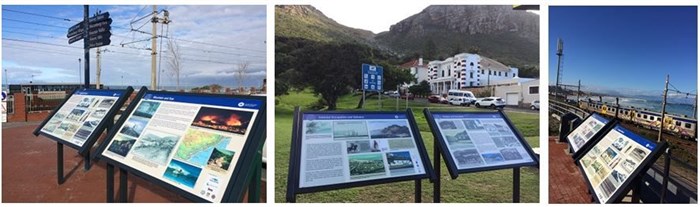
The boards tell the story of the people who lived in this part of the city centuries ago before it became an important access route dotted with railway stations and holidaymakers in modern cars, and covers a distance of approximately 4,5km.
"Locals and tourists who stroll along the new sidewalks that we have constructed along this section of the main road will see the new storyboards as they are taking in the views of the Muizenberg mountains and False Bay. Some of the boards are placed at other popular public open spaces, for instance, at the pedestrian rail crossing at York Street for those who are passing through towards Surfers Corner, and at Muizenberg Park at the corner of Camp and Main Roads," said Eddie Andrews, the City’s mayoral committee member for Area South.
"The project forms part of the rehabilitation of the main road from the intersection with Atlantic Road in Muizenberg to the intersection with Clovelly Road just past Kalk Bay. A team of experts, including a spatial historian, historical archaeologist, social historian, narrator, and the Muizenberg Historical Conservation Society and Kalk Bay Historical Association, formed part of the committee who selected and developed the themes depicted on the storyboards.
A number of archives and individual collectors contributed to this project by making their postcards, family collections and other useful photographic images available. Thus, this can be described as a collective effort by the City, local residents and non-profit organisations who are passionate about the diverse history of Cape Town," said Brett Herron, the City’s mayoral committee member for transport and urban development.
"The storyboards are cleverly designed, with maps, photos, drawings and text telling the stories of the people who have lived in this area for over 400 years. It shows how the peninsula has evolved from a food provider to a fun holiday destination, and the conflict and development that came with it. It is the collective story of our rich and diverse cultural heritage," said Herron.
"Most interesting is that freed slaves, political exiles, and Filipino mariners found a home on the False Bay coast. Families lived in mixed neighbourhoods. Fishermen from the Philippines were Catholic and St James was their patron saint. Many slaves and exiles were Muslim and summer visitors and the owners of villas attended the Jewish synagogue on Saturdays," said Andrews.
"The purpose of the storyboards is not to create a complete historical overview of the area but to give locals and tourists a glimpse of the Southern Peninsula and its people. We have worked for nearly two years on finalising this project, which is in line with the City’s new Organisational Development and Transformation Plan (ODTP). One of the outcomes of the ODTP is to build an inclusive Cape Town where we commemorate the people and events that influenced the character and culture of the city. I encourage residents to take a closer look at these boards next time they are strolling along Main Road," said Herron.